


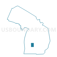
Voting District 0811850000002, Kent County, Michigan
About
Outline

Summary
| Unique Area Identifier | 597474 |
| Name | Voting District 0811850000002 |
| County | Kent County |
| State | Michigan |
| Area (square miles) | 12.40 |
| Land Area (square miles) | 12.39 |
| Water Area (square miles) | 0.00 |
| % of Land Area | 99.96 |
| % of Water Area | 0.04 |
| Latitude of the Internal Point | 43.18349280 |
| Longtitude of the Internal Point | -85.51841110 |
Maps

Graphs
Select a template below for downloading or customizing gragh for Voting District 0811850000002, Kent County, Michigan


Neighbors
Neighoring Voting District (by Name) Neighboring Voting District on the Map
- Voting District 0810116000003, Kent County, MI
- Voting District 0810116000004, Kent County, MI
- Voting District 0811420000001, Kent County, MI
- Voting District 0811850000001, Kent County, MI
- Voting District 0811850000003, Kent County, MI
- Voting District 0815692000002, Kent County, MI
- Voting District 0816908000001, Kent County, MI
- Voting District 0817446000002, Kent County, MI
Top 10 Neighboring County Subdivision (by Population) Neighboring County Subdivision on the Map
- Algoma township, Kent County, MI (9,932)
- Courtland township, Kent County, MI (7,678)
- Solon township, Kent County, MI (5,974)
- Rockford city, Kent County, MI (5,719)
- Nelson township, Kent County, MI (4,764)
- Cedar Springs city, Kent County, MI (3,509)
Top 10 Neighboring Place (by Population) Neighboring Place on the Map
Top 10 Neighboring Unified School District (by Population) Neighboring Unified School District on the Map
Top 10 Neighboring State Legislative District Lower Chamber (by Population) Neighboring State Legislative District Lower Chamber on the Map
Top 10 Neighboring State Legislative District Upper Chamber (by Population) Neighboring State Legislative District Upper Chamber on the Map
Top 10 Neighboring 111th Congressional District (by Population) Neighboring 111th Congressional District on the Map
Top 10 Neighboring Census Tract (by Population) Neighboring Census Tract on the Map
- Census Tract 106, Kent County, MI (10,270)
- Census Tract 108.01, Kent County, MI (7,652)
- Census Tract 101.01, Kent County, MI (5,871)
- Census Tract 107, Kent County, MI (5,381)
- Census Tract 102, Kent County, MI (4,137)